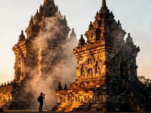
Lost in the Stone Canyons: Petra’s Urban Soul Uncovered
Have you ever walked through a city carved entirely from rose-red rock? Petra, Jordan isn’t just an archaeological site—it’s a living urban landscape shaped by centuries of civilization. As I wandered its narrow siqs and ancient plazas, I realized this was more than a ruin; it was a city with rhythm, space, and breath. This is a guidebook unlike any other—one that sees Petra not just as history, but as an urban space where architecture, movement, and culture converge in breathtaking harmony. More than two thousand years after its peak, Petra still pulses with the quiet energy of intentional design, where every carved step, hidden cistern, and sunlit courtyard tells a story of human ingenuity meeting natural grandeur.
Entering the City Through the Siq – A Natural Urban Gateway
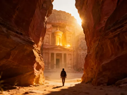
The journey into Petra begins not with a view, but with concealment. The Siq, a narrow gorge carved by tectonic forces and refined by Nabataean hands, serves as one of the most dramatic urban entrances in human history. Stretching nearly a kilometer long and in places no wider than three meters, this natural corridor is more than a passageway—it functions as a deliberate threshold, a transition from the arid openness of the desert to the sacred heart of an ancient city. The towering sandstone walls, rising up to 80 meters on either side, are streaked with hues of rust, rose, and ochre, their surfaces smoothed by centuries of wind and water. As visitors walk through, sunlight filters in narrow bands, shifting with the hours, creating a rhythm of light and shadow that feels almost ceremonial.
What makes the Siq truly remarkable is not just its beauty, but its function as urban infrastructure. The Nabataeans, master engineers of their time, transformed this natural fissure into a controlled access route. Along its length, one can still see the remains of a sophisticated water channel system carved into the rock—evidence of how water, a precious resource in the desert, was carefully managed and distributed throughout the city. Stone conduits, once covered with limestone slabs, ran parallel to the path, delivering fresh water from mountain springs to homes, public fountains, and ceremonial basins. These channels were not an afterthought; they were integral to the design, reflecting a society that understood the relationship between movement, access, and utility.
Equally important was the psychological effect of the Siq. By narrowing the path and limiting visibility, the Nabataeans built anticipation. Visitors could not see the city’s treasures until the final turn—when the Treasury (Al-Khazneh) suddenly appears, framed perfectly between the cliffs. This moment of revelation was no accident. It was a carefully orchestrated experience, akin to entering a grand cathedral or a modern city’s central plaza through a sequence of gates and plazas. The Siq controlled the pace of arrival, regulated foot traffic, and heightened emotional impact—principles still used in urban design today. In this way, the Siq was not just a path, but a narrative device, guiding the human experience of the city from the very first step.
The Treasury (Al-Khazneh) – Monument as Civic Center
Emerging from the Siq, the Treasury stands in full view—a monument so iconic it has become synonymous with Petra itself. Rising over 40 meters from the canyon floor, its ornate façade is carved directly into the cliff face, a masterpiece of rock-cut architecture. Though long believed to be a royal tomb, likely for a Nabataean king, the Treasury likely served multiple purposes, including ceremonial, administrative, and symbolic functions. Its placement at the end of the Siq ensures it is the first major structure visitors encounter, making it a powerful focal point—an anchor around which the city’s identity was organized.
The architectural style of the Treasury reveals the cultural sophistication of the Nabataeans. Blending Hellenistic influences with local traditions, the façade features Corinthian columns, a broken pediment, and sculptural details that suggest a dialogue between East and West. The central tholos, crowned with a conical stone, may have had astronomical or religious significance. Above the entrance, six eagle reliefs—symbols of protection and divine power—still watch over those who pass below. These elements were not merely decorative; they communicated authority, wealth, and spiritual connection to both citizens and travelers. In this sense, the Treasury functioned much like a modern city hall or central monument—its presence reinforcing civic pride and cultural identity.
Today, the Treasury continues to serve as a gathering place. Visitors pause instinctively upon seeing it, many raising cameras, others standing in silence. Children point, couples embrace, and elders sit on nearby stones, absorbing the scale and beauty. This spontaneous reaction mirrors how public spaces function in contemporary cities—places where people stop, reflect, and connect. The Treasury, though no longer used for rituals, still generates a sense of collective awe. Its role has evolved, but its power as a civic heart remains. It reminds us that great urban spaces are not just functional; they are emotional, designed to inspire and unify.
From Tombs to Terraces – Housing the Living and the Dead
As one moves beyond the Treasury, Petra reveals itself not as a collection of isolated monuments, but as a fully integrated cityscape. The cliffs that enclose the valley are dotted with hundreds of tombs, dwellings, and ceremonial niches, forming a vertical urban fabric. Unlike modern cities, where cemeteries are often placed on the outskirts, the Nabataeans embedded burial sites within the daily life of the city. Elite tombs, marked by elaborate façades, were carved high on the rock faces, visible from below—a constant reminder of ancestry and legacy. These were not hidden or somber places, but honored spaces, integrated into the visual and spiritual landscape.
Beneath these tombs, along the valley floor and mid-level terraces, archaeologists have uncovered the remains of residential areas. These include what are known as “terrace houses”—multi-level homes built into the hillside, supported by stone retaining walls. Constructed during the first century CE, these dwellings combined natural topography with architectural innovation, maximizing space and stability in a rugged environment. Some featured courtyards, staircases, and even rooftop access, suggesting a dense, layered form of urban living. Water channels ran alongside homes, delivering fresh supplies to households, while drainage systems protected against flash floods—a common danger in narrow canyons.
This integration of life and death reflects a worldview in which the presence of ancestors was not feared, but honored as part of community continuity. In many ways, Petra’s urban layout fostered a sense of connection across generations. Today, this contrasts sharply with modern urban planning, where residential zones, commercial districts, and burial grounds are strictly separated. In Petra, these functions coexisted, creating a holistic environment where the spiritual and the practical were not divided. For the modern observer, especially for those who value family, heritage, and belonging, this offers a poignant reflection on how cities might better honor memory and identity within everyday life.
Water, Movement, and Flow – The Hidden Infrastructure of an Ancient City
Beneath Petra’s visible grandeur lies a network even more impressive: its water management system. In a region receiving less than 150 millimeters of rainfall annually, the ability to capture, store, and distribute water was not just convenient—it was essential for survival. The Nabataeans responded with one of the most advanced hydraulic systems of the ancient world. Over 200 cisterns have been identified across the site, capable of storing millions of liters of water. These were strategically placed near residential zones, public buildings, and caravan routes, ensuring reliable access during long dry periods.
The system began in the mountains surrounding Petra, where catchment walls and diversion channels directed rainwater into conduits. These stone or clay pipes, some buried underground, transported water across uneven terrain, using gravity to maintain flow. Along the Siq, the main channel ran close to the path, supplying water to travelers and nearby structures. In the city center, distribution basins and settling tanks filtered sediment before water reached fountains or homes. During heavy rains, overflow channels and dams prevented flash floods from damaging buildings—a critical safeguard in a city built within narrow gorges.
This infrastructure was invisible to most users, much like modern sewage or electrical grids, yet it underpinned every aspect of urban life. Markets, temples, and homes all depended on reliable water access. The Nabataeans even used water as a tool of diplomacy and trade—caravans crossing the desert would stop in Petra not only for goods but for rest and replenishment. In this way, water became both a practical necessity and a source of economic power. For today’s cities, facing climate change and water scarcity, Petra’s example offers a timeless lesson: sustainable urban design begins with the careful stewardship of natural resources. The quiet efficiency of its hidden channels speaks louder than any monument.
The Street of Facades and the Colonnaded Street – Pathways of Power and Commerce
From the Treasury, the path leads into the heart of Petra’s urban core, where two key thoroughfares reveal the city’s social and economic rhythm. The Street of Facades is a row of simple yet dignified tombs, their uniform design suggesting a collective identity among Petra’s elite. Carved into a single cliff face, these structures face a broad walkway, creating a processional route where mourners and citizens alike would have gathered. Though modest compared to the Treasury, their alignment and repetition give them a quiet authority—like the facades of a historic neighborhood where tradition and status are expressed through architecture.
Further on, the remains of the colonnaded street come into view—a wide avenue once lined with rows of columns, connecting the city’s administrative and commercial districts. Though many columns now lie fallen, their bases remain in place, marking a path nearly 15 meters wide. This was Petra’s main boulevard, akin to modern city avenues where commerce, governance, and public life intersect. Along its sides, archaeologists have found traces of shops, workshops, and public buildings, suggesting a vibrant marketplace where goods from Arabia, Egypt, and the Mediterranean were exchanged.
The layout of this area reflects careful urban planning. The colonnaded street did not simply connect points; it shaped movement and behavior. The shade provided by the columns made walking comfortable in the desert heat, encouraging foot traffic and social interaction. Merchants would have displayed their wares under the arcades, while officials conducted business in nearby structures. Religious buildings, such as the Great Temple, stood nearby, reinforcing the connection between economy, governance, and spirituality. Even in ruins, the energy of this space is palpable—the echo of footsteps, the murmur of trade, the pulse of urban life. For modern visitors, especially those familiar with city markets or historic districts, this offers a powerful reminder that great cities are built not just on monuments, but on the everyday flow of people and goods.
High Places and Open Spaces – Ritual and Community in Urban Design
One of the most profound aspects of Petra’s urban design is the integration of sacred spaces into the natural landscape. The High Place of Sacrifice, perched atop a mountain ridge, is among the most striking examples. Reached by a steep climb of over 800 steps, this ceremonial platform offers panoramic views of the entire city and surrounding desert. Its elevated position was not chosen for isolation, but for connection—linking the heavens with the earth, the divine with the communal. Archaeological evidence suggests it was used for public rituals, possibly involving animal offerings, seasonal festivals, or astronomical observations.
What makes this site remarkable is its accessibility. Unlike temples hidden within palaces or restricted to priests, the High Place was reachable by many. The processional path leading to it was wide enough for groups to ascend together, suggesting that religious practice was a shared, collective experience. Along the way, smaller altars and niches allowed for personal offerings, blending individual devotion with communal worship. This design reflects a city where ritual was not separate from daily life, but woven into its movement and structure.
Today, such spaces are echoed in modern parks, memorials, and observation decks—places where people gather not just to see, but to reflect, remember, and connect. The High Place of Sacrifice, like a city garden or hilltop viewpoint, offers both physical elevation and emotional uplift. For families visiting Petra, especially mothers and caregivers who often hold families together through tradition and memory, this space resonates deeply. It speaks to the enduring human need for meaning, community, and connection to something greater. In Petra, spirituality was not confined to temples; it was embedded in the city’s very form.
Petra Today – Balancing Preservation and Urban Experience
Today, Petra is both an archaeological treasure and a living cultural landscape. Managed by Jordan’s Department of Antiquities and supported by international conservation efforts, the site welcomes hundreds of thousands of visitors each year. Carefully designed pathways guide foot traffic, protecting fragile carvings and ancient structures from erosion. Visitor centers provide context, while trained guides offer insights into Nabataean life. Local Bedouin communities, particularly the Bdul tribe, continue to play a vital role in the site’s stewardship, serving as guides, artisans, and cultural ambassadors.
Yet challenges remain. Tourism brings economic opportunity, but also pressure on infrastructure and the environment. Efforts to limit vehicle access, manage waste, and restore damaged facades reflect a commitment to long-term preservation. Digital documentation, including 3D scanning and drone mapping, helps monitor changes and inform restoration work. At the same time, there is growing recognition that Petra should not be treated as a frozen relic, but as a dynamic space where past and present coexist.
For modern urban planners and everyday visitors alike, Petra offers profound lessons. It demonstrates how cities can thrive in harmony with nature, using topography and climate to inform design. It shows how efficient use of space, thoughtful infrastructure, and cultural continuity can create resilient communities. And it reminds us that great cities are not defined by size or technology, but by the human experience they foster—movement, gathering, memory, and meaning. Petra endures not because it is old, but because it speaks to timeless needs: the desire for beauty, belonging, and a place to call home. In walking its stone corridors, we do not just witness history—we feel the enduring soul of the city.